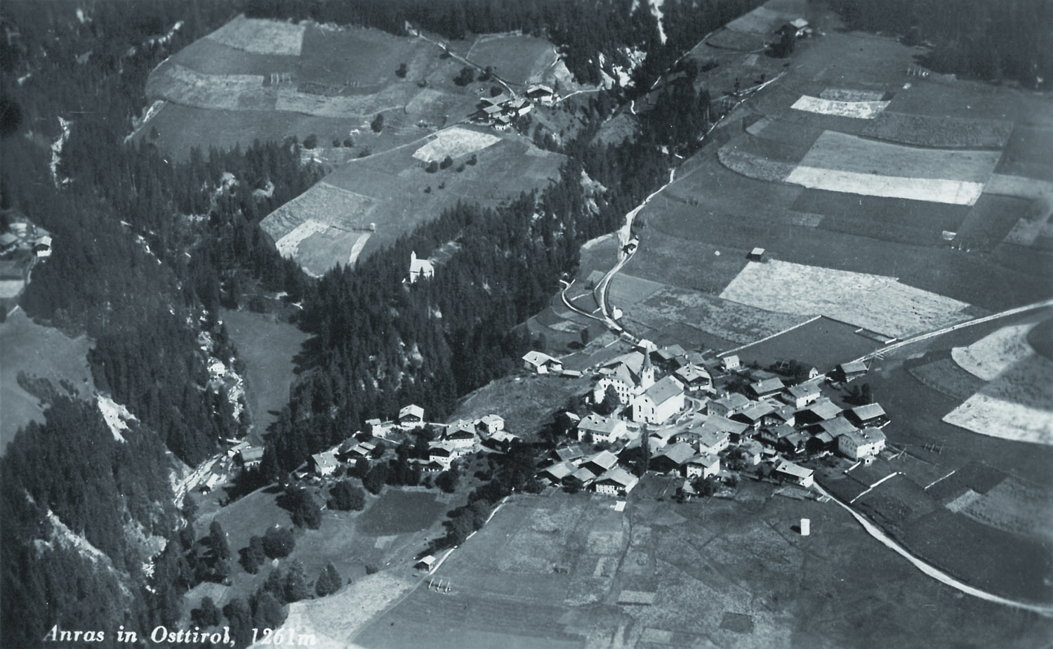
Ansicht um 1930, Foto: Gemeindearchiv Anras / Dina Mariner
Auf den sonnseitigen, fruchtbaren und nur leicht geneigten Hängen der Hochterrasse des Hochpustertales gelegen, stellte die Gegend um Anras das ehemalige Zentrum des Getreideanbaues in Osttirol dar – nicht umsonst wird die Gegend in historischen Quellen als „Kornkammer Osttirols“ bezeichnet.
Die historische Flugaufnahme aus den 1930er Jahren zeigt die ehemals kleinräumig strukturierte Kulturlandschaft des Gemeindegebietes mit einem Mosaik aus Äckern, Wiesen, Steinmauern, Holzzäunen und insgesamt über 200 Harpfen und 46 Mühlen.
Das Dorf Anras war bis in die späten 1960er Jahre das Musterbeispiel eines Massendorfes, einer Sonderform des Haufendorfes, mit besonders dicht aneinandergebauten Häusern und Regellosigkeit von Bauparzellen und Baublöcken. Erst im Rahmen der Dorfauflichtung in den späten 1960er und 1970er Jahren verlor insbesondere der östliche Teil des Dorfes fast seine gesamte historische Bausubstanz.
Der Name Anras wird erstmals in einer Urkunde von 769 erwähnt „usque ad terminos sclavorum, id est ad rivolum montis anarasi“. Die Herkunft des Namens ist noch nicht vollständig geklärt. Möglicherweise handelt es sich um ein keltisches bzw. indigenes Wasserwort „an-aro“ in der Bedeutung „Wasser, Sumpf“.
Situata sui pendi soleggiati, fertili e solo in leggera pendenza dell'alto terrazzo della Val Pusteria, la zona di Anras era un importante centro di coltivazione del grano nel Osttirol - non per niente la zona è chiamata dalle fonti storiche “il granaio del Osttirol“.
La ripresa aerea historica dell’anno 1930 rappresenta su scala, mostra com’era il suo territorio con un mosaico di parti, recinti di pietra e legna, campi per le coltivazioni ed un totale di 200 Harpfen e 46 mulini.
Fino alla fine degli anni ‘60, Anras aveva quale caratteristica la sua speciale conformazione urbanistica. Un agglomerato di case, costruite l’una a ridosso dell’altra, senza alcuna di distanza fra loro. Negli anni che vanno dal 1960 al 1970 la parte ad Est del paese perse, in seguito al suo ridimensionamento, il vecchio aspetto storico.
Il nome Anras menzionerò in un documento dell’anno 769: “usque ad terminos sclavorum, id est ad rivolum montis anarasi”. L’origine del nome non é chiarito completamente. Forse si tratta d’una parola celtica “an – aro” che significa “l’acqua, la palude”.
Situated on the sunny, fertile and only slightly sloping slopes of the high terrasse of Hochpustertal, the area around Anras was an important center of grain cultivation in East Tyrol - it is not for nothing that the area is referred to in historical sources as the "granary of East Tyrol".
The historical aerial photograph from the 1930s shows the then still more strongly small-scale structured cultural landscape of the municipal area with a mosaic of fields, meadows, stone walls, wooden fences and a total of over 200 Harpfen and 46 mills.
Until the late 1960s, the village of Anras was a prime example of a mass village, a special form of the cluster village, with houses built especially close to each other, and building plots and blocks of buildings lined up randomly. It was not until the clearing of the village in the late 1960s and 1970s that the eastern part of the village in particular lost almost all of its historical building fabric.
The name Anras is first mentioned in a document from 769: “usque ad terminos sclavorum, id est ad rivolum montis anarasi”. The origin of the name has not yet been fully clarified. Possibly it is a celtic or indigenous water word "an-aro" in the meaning of "water, swamp".
 Gemeinde
  Abfallratgeber
 Tierkadaver - Annahmezeiten/Kosten